 |
|
||||
|
EBRANTA Home : Products : TopoPoint Canada for iPhone TopoPoint Canada To purchase, please vist the iTunes App Store
NRCan topographic maps contain the highest detail of any map suitable for wilderness travel within Canada. TopopointCAN downloads these maps from an NRCan server and stores them on your iPhone. • Heading to the 2010 Winter Olympic sites in BC? Please see the TopoPoint Canada Olympic Quick Start Guide. TopoPoint Canada features: • Multiple map scale support with "pinch and zoom" viewing. TopoPoint Canada displays maps at 2, 4, 8, 16, and 64 meters per pixel. Map resolution is selected from the main view, and when maps are downloaded from the NRCan server. Simply tap the numbered scale indicator button above the bottom toolbar to select a different map scale. • Conserve device resources by only downloading useful map data. TopoPoint Canada's selectable map resolution feature enables complete user control over downloaded map data. The user is NOT forced to waste device space, battery, and time downloading and viewing map data that is not useful for their particular purpose. The user also has complete control over which map resolution is displayed. TopoPoint Canada will NOT unexpectedly switch to a different map resolution while zooming - this prevents unnecessary reloading of map data into the main view. • Offline Map availability. Simply download maps of your choice directly to TopoPoint Canada's Map Case before departing the cellular data service area or WiFi connection. Your maps will be available anywhere and viewable in the main screen! TopoPoint Canada eliminates the need for a computer to usher map data between the Internet and your device. The map name is chosen by the user and displayed on the main screen when in use. To browse a saved map in the main screen, just select it in the map list and return to the main TopoPoint Canada screen. Map data size is displayed in kilobytes (KB) for each map in the map case. • Robust scrolling main map view that moves seamlessly across quad boundaries.
• Automatic offline or online operation. When located within a cellular data service area or connected to WiFi, TopoPoint Canada will automatically download and display map images for your current, or browse location. When offline, TopoPoint Canada will automatically display stored maps in the main screen. When in locate mode, the GPS position indicator will automatically display your position on offline saved maps in the main screen. • Main view GPS Position display with accuracy and map scale information. TopoPoint Canada features an innovative GPS position indicator with integrated radial map scale and GPS accuracy information. Scale and GPS altitude can be displayed in English or Metric units. The inner scale circle is 100 yards or meters from the location, the outer circle is 200. • Powerful Browsing capabilities with position display.
• Real Compass dislpays Heading. TopoPoint Canada uses the iPhone/iPad compass capabilities to display true or magnetic north. NRCan maps are displayed in true north convention so using magnetic north is not recommended. When set to true north, the compass needle will not be displayed if the iPhone hardware cannot determine true north. Moving the iPhone in a vertical and horizontal circular motion will aid in calibration of its internal magnetometer, and improve true north calculation performance. The iPhone hardware/firmware determines heading values and magnetic declination in "real time" and is not affected by the earth's magnetic field "drift". • GPS Motion overlay display! Great for skiing (see Tip below).
• Fully featured Waypoint capabilities, with automatic timed Waypoint creation "Tracks". TopoPoint Canada creates Waypoints with a single main screen button press. Current GPS location or browse location is recorded by simply tapping the coordinate display text button in the bottom toolbar. Waypoints can also be entered manually. UTM coordinate and creation time are also recorded for each Waypoint. GPS altitude is recorded for Waypoints created with GPS position. Waypoints are stored in user definable Waypoint Sets and can be emailed via the iPhone's mail application if a user account is set up on the iPhone.
Waypoints can be copied directly between waypoint sets. • Map cache management feature allows precise control of device memory usage. In order to provide optimum performance, TopoPoint Canada employes a map cache to store map data that is not currently in the map case. This cache can be cleaned without removing downloaded maps that reside in the map case. Please see the TopoPointUSA user manual for details. • 'Go' Screen allows quick jump to any coordinate.
• Browse to Area using arial/street view!
When invoked from the map case view, the '+' button is displayed. Pressing the '+' button will open the standard create map view, with the topographic preview centered at the browse location. System requirements: GPS features require a device with GPS capabilities. Compass feature requires a device with Compass capabilities. iOS version 4.3 or later. The NRCan map images displayed by TopoPoint Canada are only available for locations within Canada. This application cannot display maps for locations outside Canada. While NRCan topographic maps are excellent for wilderness travel, they are not intended to be road maps and are not suitable for roadway use. Please also be advised that this application is not intended to be an automatic "turn-by-turn" navigation system, and cannot replace common sense wilderness navigation skills. We encourage users to gain proper wilderness navigation and safety training before traveling to remote areas.
|
 Introducing TopoPoint Canada, a wilderness navigation tool for displaying FREE Natural Resources Canada (NRCan) high resolution topographic map images and your GPS position whether you are online or not!
 As your GPS position changes the map will automatically track in the direction you are traveling. "Swipe" scrolling away from your current location invokes browse mode. Pressing the 'locate' button resumes tracking of your current GPS position. Coordinates are displayed in decimal degrees format.
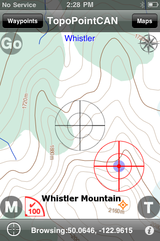 TopoPoint Canada also includes advanced main view browsing capabilities. Detailed Latitude and Longitude coordinates are displayed when browsing map images away from your current location. A precise browse position indicator with map scale is also displayed when browsing.
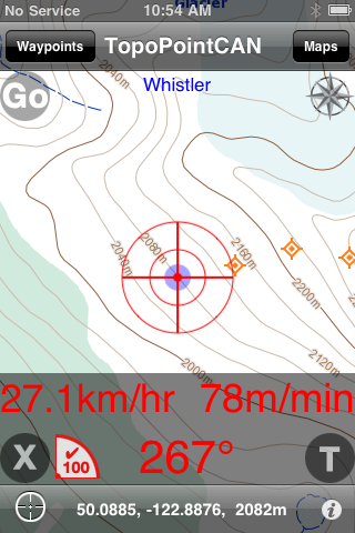 Pressing the 'M' (motion) button on the main screen displays an overlay view containing GPS course, horizontal and vertical speeds. The motion button can be hidden by disabling the feature in preferences.
 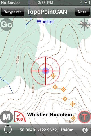 Enabling the 'T' (Track) button allows automatic creation of timed Waypoints based on a user defined interval (1-60minutes). Waypoint sets can contain a maximum of 240 waypoints each. If this number is exceeded, a new set is automatically created with a numbered suffix. New timed, or on-demand Waypoints will then be added to the newly created set.
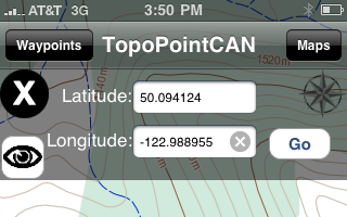 Coordinates can be obtained by browsing an arial/street map view (see below). Latitude and Longitude values are set in the 'Go' screen fields when searching or browsing is complete. Pressing 'Go' will then 'jump' the main screen to the Topographic map of the area.
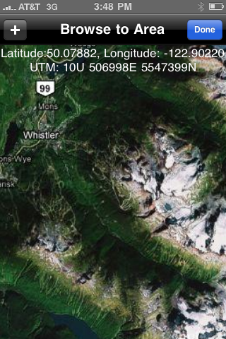 Browsing to an area using the arial/street view can be used to jump to a coordinate, or when downloading a map to the map case. The view can scroll and zoom to any location in the world, just like the iPhone's native map application.