 |
|
||||
|
EBRANTA Home : Products : TopoPointCAN Olympic Quick Start TopoPoint Canada To purchase, please vist the iTunes App Store
• Whistler Blackcomb area Maps:
To complete each map, simply press the '>' disclosure button to view the map parameters, then press the create button at the bottom of the map details view. This must be done for all three predefined maps. TopoPoint Canada will continue to download maps while it is running, even if you return to the map case view or the main screen. If TopoPoint exits for any reason (e.g. an incoming call), downloading of map data stops.
Also note that the map name can be changed to remove the "Sample…" help text. • Downloading additional maps: In addition to the sample maps, new maps can be defined and downloaded. Simply open the map case and press the browse (eye) button. Then browse to the desired area and press the '+' button. This will display the new map details view. Enter the desired parameters including size and scale, then press create. • Waypoint Data: Sample waypoints are also predefined for the various wilderness Olympic venues. This data is useable as is. No additional setup steps are required. $$$ Data Connection: Once you arrive in Vancouver, we recommend using a Wifi connection to download maps if you normally reside outside Canada. Rogers Wireless is the iPhone service provider in Canada and their data roaming rates are quite expensive if you don't have a data roaming plan. Please consider this issue carefully to avoid tremendous data roaming expenses. Data Roaming can be turned off in iPhone settings under General->Network. We also recommend disabling 3G service if Data Roaming is turned off, this will extend battery life. Return to the TopoPoint Canada product description
|
 TopoPoint Canada installs from the app store with sample map and waypoint data predefined for the 2010 Vancouver Olympic games. The tips in this quick start page will aid in the quick setup of this data. Completion of this setup requires a data connection (see below).
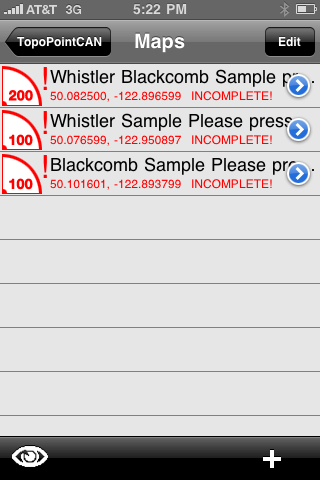 After installing TopoPoint Canada, three predefined maps for the Whistler Blackcomb ski area appear in the Map Case. While the coordinate, size, and scale parameters are defined for these maps, the actual map data is NOT present on the iPhone yet. This is indicated by the "INCOMPLETE!" red label beneath the map title in the map case (see image to the right). TopoPoint Canada must download the map data from the Natural Resources Canada server before these maps are useable.
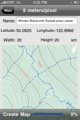 To continue downloading of map data, TopoPoint must be relaunched and each map must be restarted from the map details view. Downloading will resume from where it left off when TopoPoint exited. The amount of remaining data required to complete the map is also displayed at the bottom of the map details view.